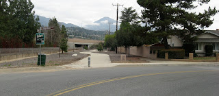
Now, as we know, riding against traffic is a no-no, dangerous stuff. It is even more perilous here, because the two right lanes of the 210 exit are right turn only lanes and, while drivers are directed to turn on a green light only, it does not always happen that way.
Next is this neighborhood entry/exit point, nicely laid out, landscaped, I assume at least minimally maintained, and... fenced off. Classical case of NIMBYISM? Why go to all the trouble to design and build, just to fence it off?
Roughly halfway along its course the pathway makes a roughly 90º turn away from running parallel to the 210, and now runs parallel to the Thompson Creek Channel. Again, nicely, though minimally maintained. The path soon ends where Sumner Avenue bends into Ridgefield Drive. If you take Ridgefield, ride for about a quarter mile, you will find yourself back at Towne, almost where, and a literal stone's throw from where, you started.
What would be useful is to have the path continue south along Thompson Creek (right through the gate in the photo below). Instead you get an on street bike lane, which is all well and fine, but the lane is one of those kind in which cars can park, rendering it utterly useless in its intended purpose.
The map below shows the path highlighted in red. From a pedestrian standpoint, I suppose it makes some sense as a connection from the residential area to the Thompson Creek Trail above Baseline, but enough sense to justify the cost? I don't see much advantage afforded by the pathway over the Ridgefield/Towne alternate route. Anyway, there you have this little Claremont spatial oddity. It seems to want to be a part of something more significant, but just feels incomplete and leaves a "what is it for" taste in your mouth.
Alright, so, I was talking to a couple city council candidates this past Sunday and was provided a little more insight. This little section of the Thompson Creek Trail has the potential to serve as a starting point for a bikeway connecting to the San Gabriel River Trail in Whittier. The path would continue southwest along the Thompson Creek channel, connect to San Jose Creek, and then follow that channel to its confluence with the San Gabriel River. I am not aware of any plans in motion at the time to bring this to reality, but wow, what potential. To be able to ride from Claremont to Seal Beach on a dedicated class 1 bike path - where do I sign up? By following these creek channels, the path would be about the most direct route to the coast that you could expect to find. Actually, if you check out the Metro Bike Map you will see that lower San Jose Creek, where it meets the San Gabriel already has a class 1 path; with both ends in place, we just need to fill in the middle, and link to the SGRT over the river. Obviously something like this is an involved process, involving many jurisdictions, numerous right-of-way issues, awkward street crossings, naysayers, and funding issues, but it has been done before, and there is no reason it cannot be done again. With a little effort, this little oddity could be turned into a gateway.


No comments:
Post a Comment